The numbers are spitballed from memory, the important bit is that it went to a crazy altitude and made a lot of jumps, but between most of those jumps it stayed level. I'm assuming this altitude data is on a separate route from the one I posted earlier, it sounds more like something a military training flight would be doing though (the altitude jumps)
Here's the site that's been getting a tonne of posts, there's a lot of pilots on here so there's good info, but it's a lot of reading. I think the stuff on the altitude jumps was thread 20 or 21
MH370 Malaysia Airlines B772 Missing Enroute KUL-PEK Part 24 — Civil Aviation Forum | Airliners.net
They have a very good summary at the top of every thread for those wanting a Coles Notes.
edit: found the initial altitude info
Quote:
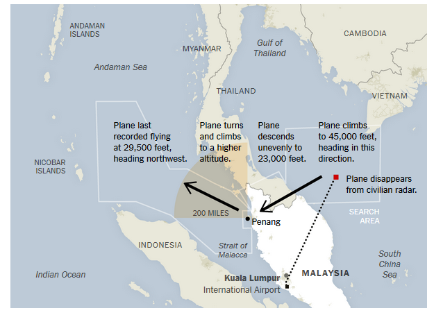
Malaysia Airlines Flight 370 experienced significant changes in altitude after it lost contact with ground control, and altered its course more than once as if still under the command of a pilot, American officials and others familiar with the investigation said Friday.
Radar signals recorded by the Malaysian military appear to show the missing airliner climbing to 45,000 feet, above the approved altitude limit for a Boeing 777-200, soon after it disappeared from civilian radar and made a sharp turn to the west, according to a preliminary assessment by a person familiar with the data.
The radar track, which the Malaysian government has not released but says it has provided to the United States and China, then shows the plane descending unevenly to an altitude of 23,000 feet, below normal cruising levels, as it approached the densely populated island of Penang, one of the country’s largest. There, the plane turned from a southwest-bound course, climbed to a higher altitude and flew northwest over the Strait of Malacca toward the Indian Ocean.
Investigators have also examined data transmitted from the plane’s Rolls-Royce engines that shows it descending 40,000 feet in the space of a minute, according to a senior American official briefed on the investigation. But investigators do not believe the readings are accurate because the aircraft would likely haven taken longer to fall such a distance.
“A lot of stock cannot be put in the altitude data” sent from the engines, one official said. “A lot of this doesn’t make sense.”
|
It doesn't sound as solid as the other route tracking report tho.
edit 2: Sounds like the altitude info is along the same route as posted before. From the NYTime article
http://www.nytimes.com/2014/03/15/wo...adar.html?_r=0